Todays Distance: 102 miles
Cycling time: 8hrs 17 mins
Average Speed: 11.9 mph
Today’s cumulative ascent: 3435 ft
Average Heart rate: 99 bpm
Distance so far: 1451 miles
Ascent so far: 58,268 ft.
Centuries so far: 3
Punctures so far: 2
Distance so far: 1451 miles
Ascent so far: 58,268 ft.
Centuries so far: 3
Punctures so far: 2
Today’s Profile: 
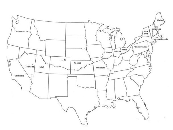
Today’s Route:

Dedication: Today is for all those children in Providence including Skhembor and Khrawbok who keep me going even when the going gets tough. If you can do it……then I can do it.
Today’s Route:

Dedication: Today is for all those children in Providence including Skhembor and Khrawbok who keep me going even when the going gets tough. If you can do it……then I can do it.
With certain relief that Monarch Pass was behind us I expected that to-day should be easier. The profile looked favourable and we all assumed (see Heard Today below) that the cycling would be a doddle. Dangerous to assume anything. But it was a game of two halves.
 An early departure was called for as there were thunder storms predicted for the Pueblo for the late afternoon and it would be advisable to be in prior to those breaking. My alarm was off at 4.45 am with loading at 5.30, and departure shortly after 6. I reckoned that we’d see Pueblo by noon. It was colder than usual, especially when we cycled into the shadow of the mountains ….a difference of 5 degrees between shade and sunlight. We knew that it would warm up as the morning wore on and that heat could be an issue before the end of day.
 I wore my Xilinx shirt today (see Thursday May 29) as I was passing through Colorado. A few looked at me twice at breakfast not recognising me without the Providence shirt. But they did admire it, it being a unique issue.
 The early hours of today’s cycle saw us cycling along Highway 50 accompanying the Arkansas River as it raced downwards towards the Mississipi over 1200 miles away. As we cycled along the headwaters of this main tributary of the Mississippi-Missouri system it was a torrent as a result of the melting snows.
 Every few miles there were slipways and advertisements for white-water rafting but we were iut a bit early to see the action. As we approached the first SAG stop the busses were bringing rafts and rafters well upstream for an adrenaline-filled day. Here as a mountain torrent it drops 4000 feet in 100 miles
 The water in the Arkansas seemed to be cascading as fast as we were moving. If I had thrown in a 7-Up bottle as we left I feel it would have been in Pueblo as fast as us. (as things panned out, it would have been in the Mississippi itself !)
 Cycling through the Arkansas canyon was beautiful –every turn and bend brought a new postcard. My head was continuously turning from the river to the rock formations above and the smaller canyons.
We moved along at an effortless 18mph turning the big ring always descending and the day slowly warming up. Pure heaven. Our group of 4 (later to expand to 5) was an international one – Trinidad, Australia, Netherlands and Ireland (the later extra from New Zealand).
 An odd stop was made for photos but I regularly snapped from the saddle. I have taken an average of 100 photos per day so far. I could possibly lose a lot of friends when I return home should I ever mention to them in a dull moment in conversation ‘Did I ever show you my holiday snaps?’
First SAG was at mile 37 in a lay-by on the bank of the river. Everything had been in our favour. This was the first half –playing with the wind and the hill. By this stage sunscreen needed to topped up and bottles refilled.
 A suggestion had been made at Route Rap yesterday evening that a bit of an optional detour (an extra 8 miles and a bit of a short sharp climb) would bring us to the Royal Gorge (not the Royal George). I was all in favour of doing it; others were easy about it so we went. The reasoning was that this was a downhill day and a Rest Day tomorrow and we could make another century out of the day’s 95 miles. As it turned out the short sharp climb was a taxing one. By the end of the day we may have regretted doing the extra but the Gorge was spectacular. Possibly we just spent too much time there.
 The Royal Gorge on the Arkansas River has the highest suspension bridge in the world –1053 feet above the surface. I noted an unnecessary notice as I cycled over ‘No fishing from the bridge’! The bridge itself is surrounded by a veritable theme-park with animal reserve, cable-car, funicular to the bottom etc.
 I got to close quarters with buffalo at last – lovely cute animals !!
 Today a rally of Prowler cars centered on the bridge – 60 on all from all over the world. All had personalised plates and one with the registration RTE 66 – could it have been Gay or Pat ?
 Cycling over the bridge (880 feet and 18 feet wide) I could sense a little swaying but it was something else to look down to the river. ‘That’s 1053 feet – and we have climbed 50 of those since we started ! And we’ll do another 50 before we finish ! Unbelievable.
Spent too much time there looking and having ice-cream and to cap it all I had a flat when it was time to move on – front wheel again. But every cloud has a silver lining, they say. It happened outside a restaurant in the shade and beside a park bench. Couldn’t have happened in a better place. Didn’t take long to replace the tube. Speaking of clouds. Just then large drops began to fall. Prowlers began to cover up and we surmised that these thunderstorms were arriving a bit early. Fortunately, it all passed off without the ground getting seriously wet. It had been a worthwhile detour.
3 more miles brought us back on the days route and we looked forward to continue our course down by the Arkansas as far as Pueblo in no time at all.
 Stopped off in Cañon City for a bite of lunch. Resuming the journey and all started to change. Still had 40 miles to cover. Outside Cañon we were into rolling hills – no problem in that– but then the headwind started to strengthen and strengthen. We had to pedal hard to maintain 10 mph on the downslope even and dig deep on the rise. The miles moved very slowly on the cyclocomputers. And still over 30 miles to go.
 The crests of hills just kept coming at us. Never-ending. It took effort to just remain positive. Jeff who was visibly finding it hardest was the one to keep spirits up with constant good humour in the face of adversity.
Second SAG at 70 miles and the wind was still as strong as ever. No easing but it did switch into a vicious sidewind coming in from the left.
 The heavy storm-clouds were off to our right so we had missed that. This was the first less-than; friendly cloudscape we had seen since leaving San Francisco three weeks ago. Those who were in the motel earlier had escaped the worst of this wind.
 Eventually the beginning of the Pueblo sprawl appeared and spirits lifted. We knew that we were almost there even though we had more than likely missed Route Rap for Monday. Route Rap at the end of a section (today is the end of the Rockies Tour) is special as we bid farewell to those who are about to leave us. Sorry to have missed that.
 Our motel, Days Inn, finally appeared at 6.15. We had been on the road for 12 hours with just over 8 hours cycling. But we had prevailed. High fives all round. A phone call to Margaret and a shower worked wonders (remember www) and by 7.00 it was off down to the Golden Corral for dinner. Had a steak from the buffet and it was delicious. Felt that I had earned it.
It certainly was a tough day but then the heart-rate was under 100 principally on account of the easy first half. The upcoming Rest Day was something to look forward to. Hard going; long hours; plenty of pedalling but for you kids in Providence if it all means that we raise funds for your school, it is all well worthwhile. Hang in there, man.
Thank God for the health and thank God for the energy.
Heard today: “Never just assume; it often makes an ASS out of U and ME”.


 Our usual group for this special day. We have an agreed strategy and maintain contact throughout. On some days riders join in for periods.
 The early part was through farming land with plenty of green pasture and the upper reaches of the Gunnison River coming against us. Wide open pasture, small farmyards and very few animals to be seen and no tillage.
 All the rivers were flowing to capacity as a result of the snow melting higher up in the Rockies. Some water was taken off into trenches and was to be seen lodging in grass fields. All rivers since the start of the cycle have been flowing against us; all this water will end up in the Pacific; we have been cycling up these river valleys. But all this is to change later in the day.
 First SAG came after 29 miles at the entrance to Monarch Valley Ranch in a most scenic spot. All bottles filled and bananas taken to fuel the system for the climb ahead.
  In conversation to someone I mentioned the original expansion of WWW of internet repute. You know what it is? Will tell you at the top.
 We knew that the climb up to Monarch’s pass was going to be 9 miles and that knowledge in itself was beneficial…..no wondering if the top would be around the next corner. That would have been a recipe for disaster.
 The climb started at milepost 190 and these posts spelled out our progress upwards. We maintained a rate of 5.5 mph in the early stages and completed the climb at the rate of 4.5 mph. Thus it was a 2 hour task but luckily the heat was pleasant and no adverse wind.
 The climbing was constant and unforgiving……no level bits where you could ease back. It went on and on and on at a constant 6% gradient..

 Trucks going up were growling and those coming down seemed to be racing in their low gears. When a line built up the smell of brake-liners took over from the trees on our right.
 We stopped once to take on water and twice to look back at the distance we had come up and take a few photos but never long enough for the muscles to cool down. The air was getting thinner; we were now at 10,000 feet and my ears popped repeatedly but with no discomfort. I found the only difficulty in breathing at the very start. Once I got into my groove and maintained the constant pedalling, the breathing and the heart-rate caused no panic. I was pleased at the end of the day to record a remarkably low average heart-beat…105 bpm.
 Like all good things it had to come to an end. The 9 miles completed, there was a shout of joy as we spotted the SAG wagon above. We were there at 12.15 pm.with perfect weather and the snow still on much of the ground.
 Shouts of ‘Congratulations’ and ‘Well done’ exchanged by cyclists and high fives all round. A great feeling of euphoria. We had conquered the beast. We felt on top of the world and amazingly no one was panting or gasping for breath or dropping with aching limbs. This had to be a very special Kodak moment to record our achievement. Not everyone gets the opportunity.

 No one was keen on moving off too quickly; it had taken too much effort to get up here. Quite a few took the gondola up another 700 feet to view the many peaks of the Rockies over 14,000 feet. It was freezing with a blasting bitter wind outside. Not tempted to stay too long.
 It was something else. This was the great divide stretching away into the distance.
 Inside the viewing station I had a foot in both camps, straddling the world like a Colossus. The public are asked to put a pin on the map of the world indicating their place of origin..I was the first pin in Ireland and in the visitors book I entered my comment in Irish.
  To let you in on an important piece of information. WWW is the company motto.....and don't forget it!
 A 10 mile descent lay ahead of us and I didn’t wish it to pass by in a whirr. Not a day for heroes.
  The three of us took our time and made more stops on the descent than on the ascent. It was fabulous. The whole day was fabulous. It had been a permanent smile…so wonderful.
 Around each corner of the descent I could feel the temperature rising accordingly and after 10 miles (pedals inactive) it was a level cycle into Salida where we overnight in the Gateway Inn
 At 3 pm we checked in and headed for the showers….the smiles of satisfaction still on our faces.
 Today's Route:

 An early start needed to avoid the afternoon heat so my alarm went off at 5 am. Great to be up at that hour! Loading completed at 6.30 and already the Ride the Rockies cyclists were on the road. No bunching or jostling but passing and being passed with a greeting or encouragement being exchanged.
 We had our usual SAG stops, but the stops for the larger group were like towns on market day. It was similar at the few small towns along the way and on both summits. Their group had all sizes and shapes; young, mature and older; various types of bikes- orthodox, recumbent, tandem, wheelchair using their hands and I spotted a one-armed cyclist cruising up the climbs.
 The first climb started 3 miles outside Montrose and lasted for a good 2 miles and we had to cope with the ever-present headwind along that stretch of road. The gradient was gradual and our group just kept turning away. In time the summit was attained and bottles replenished. All along this climb we were in greenery – a change from the lat ten days. At times it seemed I was cycling up by Hollyford and on towards Dolla. Great cycling area. The road climbed and turned so we had new views regularly.

 The descent in itself (3 miles), we knew, would be gratifying, but the scenery was so beautiful that I slowed up just to take it in and attempt to capture it on film. But, it was all around and above and below and every turn and twist on the road brought a new picture-postcard. It’s better that a few photos should tell the tale.
 The descent brought us back to the banks of the Gunnison River as it rushed strongly against us. One could imagine a group rafting on its strong current. Passing through the small town of Cimarron just gave us a little relief before the big climb. My front tyre had gone a bit soft and needed a couple of pounds. My fear was that it was a slow puncture but it stayed hard for the rest of the journey. Will need to recheck before we set off in the morning.
 And there on top was our own SAG stop with goodies and more water. At 8,822 feet, snow was still on the ground just across from us .
 From here to the end it was a series of descents around rocky corners and then small climbs as the mercury was beginning to climb. I can see why they are called the Rockies. Every mile brought a surprise and a gasp.
 It was amazing how peaceful it became on this section of the route. During short periods when there was no cyclists coming up behind, the surroundings were the essence of peace with not a noise in the world but the sound of birds. We had our stops for photos and to enjoy the peace. Let the world rush by; this experience (sights and sounds) is unique.

 Today the waters were calm and peaceful and only disturbed by a few fishermen. We spent almost 2 hours moving along by the reservoir.
 The final 10 miles into Gunnison finally brought us through an amount of farmland and we arrived at the motel at 1 pm. Wyatt Earp and Doc Holliday were in Gunnison in 1882 shortly after the ‘gunfight at the OK Corral’ We had arrived in different circumstances but sharing Earp’s stated philosophy of gunfighting (we apply it to cycling) “Stay calm, keep your mouth shut, take your time and only ‘figger on pullin’ the trigger once”. An early finish for us today. So early, that our rooms were not ready yet. Must slow down tomorrow! The three of us had stuck together all day and our steady even pace paid dividends. I feel we still have fuel in the tank for Monarch Pass tomorrow.